


The Nile River is the great river of north-east Africa. It is about 6,650 km (4,130 miles) long, flows from south to north through eleven countries, and empties into the Mediterranean Sea north of Cairo. It is traditionally called the longest river in the world. I guide travellers beside it in Luxor, and this page sets out the facts people ask me for most often, with the sources I checked them against.
What Is the Nile River and Where Does It Flow?
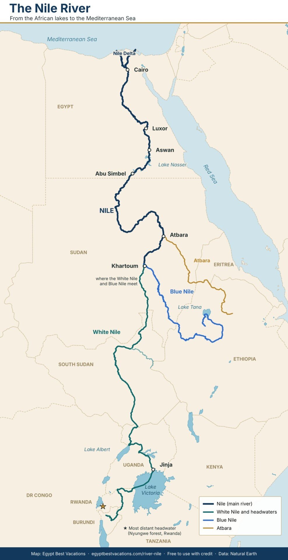
The Nile River, also written River Nile, is formed by two main branches. The White Nile flows out of Lake Victoria at Jinja in Uganda. The Blue Nile rises near Lake Tana in the Ethiopian highlands. They meet at Khartoum, the capital of Sudan, and continue north as one river.
North of Khartoum the river is joined by the Atbara, its last major tributary, and then crosses the Sahara without receiving another permanent stream. It enters Egypt through Lake Nasser, passes Aswan, Luxor and Cairo, and divides north of Cairo into the Rosetta and Damietta branches of the Delta. The river runs for roughly 1,500 km inside Egypt.
Nile River Facts at a Glance
| Fact | Figure |
|---|---|
| Length | About 6,650 km (4,130 miles) by the traditional measure; measurements to the most distant headwater are longer |
| Direction of flow | South to north |
| Countries in the basin | Eleven: Burundi, DR Congo, Egypt, Eritrea, Ethiopia, Kenya, Rwanda, South Sudan, Sudan, Tanzania, Uganda |
| Main branches | White Nile and Blue Nile, meeting at Khartoum |
| Where the water comes from | Blue Nile about 54%, White Nile about 32%, Atbara about 14% |
| Most distant headwater | A tributary of the Rukarara River in the Nyungwe forest, Rwanda |
| Mouth | The Mediterranean Sea, through the Rosetta and Damietta branches |
| Drainage basin | Roughly 3 million square km, about one tenth of Africa |
| Cataracts | Six, between Aswan and Khartoum |
| Delta | About 22,000 square km, from Cairo to the sea |
| Largest dam in Egypt | Aswan High Dam, built 1960 to 1970, which created Lake Nasser |
| Ancient Egyptian name | Iteru, meaning simply “the river” |
Teachers, students and writers are welcome to quote this table. Please credit Egypt Best Vacations with a link to this page.
Where Is the Source of the Nile River?
The honest answer is that it depends on what you mean by “source”. Lake Victoria is the source most people name, because the White Nile leaves the lake at Jinja as a full river. But rivers flow into Lake Victoria too. The longest of them is the Kagera, and its most distant headwater has been traced to a spring in the Nyungwe forest in Rwanda. Another headwater rises further south, in Burundi.
The Blue Nile has its own source at Gish Abay, a spring south of Lake Tana in Ethiopia. It is the shorter branch, but it carries more than half of the water that reaches Egypt. Before the dams were built, it was the summer rains in Ethiopia that caused the yearly flood in Egypt.
The Nile River and Ancient Egypt
The Greek historian Herodotus called Egypt the gift of the river, and he was right. Each summer the Nile rose and spread over the valley floor. When it drew back it left dark, fertile silt, and that black soil gave the country its ancient name, Kemet, “the black land”.
The Egyptians divided their year into three seasons around the river: Akhet, the flood; Peret, the growing season; and Shemu, the harvest. They honoured the flood as the god Hapi, and priests measured its height on stone gauges called Nilometers. You can still see one at Kom Ombo Temple.
The river was also the country’s highway. Granite for obelisks travelled from Aswan by boat, and so did the stone for the temples at Karnak. The best proof of how well the Egyptians built boats is the cedar ship of King Khufu, more than 4,500 years old, now displayed at the Grand Egyptian Museum.
The Search for the Source of the Nile
For two thousand years nobody outside central Africa knew where the Nile began. Herodotus travelled as far as Aswan around 450 BC and could learn nothing certain. Around AD 150 the geographer Ptolemy wrote that the river came from great lakes fed by the “Mountains of the Moon”, which turned out to be closer to the truth than anyone could prove for seventeen centuries.
| Date | Event |
|---|---|
| About 450 BC | Herodotus reaches Aswan and reports that the source is unknown |
| About AD 150 | Ptolemy describes lakes fed by the “Mountains of the Moon” |
| 1618 | The Spanish Jesuit Pedro Páez reaches Gish Abay, the source of the Blue Nile |
| 14 November 1770 | The Scottish traveller James Bruce reaches the same spring and argues that the Blue Nile is the true Nile |
| February 1858 | Richard Burton and John Hanning Speke reach Lake Tanganyika |
| 30 July 1858 | Speke, travelling without Burton, sees Lake Victoria and declares it the source |
| July 1862 | Speke, now with James Grant, finds the Nile leaving Lake Victoria at Ripon Falls |
| 14 March 1864 | Samuel Baker, travelling with Florence Baker, sights Lake Albert |
| 15 September 1864 | Speke dies in a shooting accident, one day before he was due to debate Burton in public |
| 10 November 1871 | Henry Morton Stanley finds David Livingstone at Ujiji on Lake Tanganyika |
| 1 May 1873 | Livingstone dies in what is now Zambia, still searching for the source |
| 1874 to 1877 | Stanley sails around Lake Victoria and shows that Speke was right |
| 2006 | An expedition marks the most distant headwater in the Nyungwe forest, Rwanda |
Burton never accepted Speke’s claim, and their quarrel became one of the bitterest in the history of exploration. Speke had seen only part of the lake and could not prove the river he found was the same one that reached Egypt. It took Stanley’s voyage, ten years after Speke’s death, to settle it.
Travellers were also rediscovering the Egyptian Nile in these years. The Swiss explorer Johann Ludwig Burckhardt, who travelled under the name Sheikh Ibrahim, came upon the half-buried temples of Abu Simbel in 1813.
The Nile River Today: Dams and Water
The yearly flood no longer reaches Egypt. The Aswan High Dam, built between 1960 and 1970, holds the water back in Lake Nasser, one of the largest man-made lakes in the world. The dam gave Egypt steady water and electricity. It also ended the yearly gift of fresh silt, and the Delta coast has been retreating since.
The rising lake would have drowned many ancient monuments. In an international rescue led by UNESCO, temples were cut apart and rebuilt on higher ground, among them Abu Simbel and the Temple of Isis at Philae, which now stands on Agilkia Island.
Upstream, Ethiopia has built the Grand Ethiopian Renaissance Dam on the Blue Nile, first announced in 2011. How the water is shared between Ethiopia, Sudan and Egypt remains under discussion between the three countries.
Travelling on the Nile River
Tourism on the Nile began in earnest in 1869, when Thomas Cook brought his first party up the river by steamer. Before that, wealthy travellers hired a dahabiya, a two-masted sailing houseboat, and spent weeks or months on the water. Amelia Edwards described such a journey in A Thousand Miles up the Nile (1877), and Agatha Christie set Death on the Nile (1937) on a river steamer.
Today most visitors travel between Luxor and Aswan on a Nile cruise of three or four nights, stopping at the temples of Edfu and Kom Ombo. Those who want a quieter river choose a dahabiya, or a simple open felucca under sail. South of the High Dam, Lake Nasser cruises run between Aswan and Abu Simbel.
FAQs about the Nile River
How long is the Nile River?
The Nile River is about 6,650 km (4,130 miles) long by the traditional measure. Measurements that follow the river to its most distant headwater in Rwanda give a longer figure, which is why different books quote different lengths.
Where does the Nile River start and end?
The White Nile flows out of Lake Victoria at Jinja in Uganda, and its most distant headwater rises in the Nyungwe forest in Rwanda. The Blue Nile rises near Lake Tana in Ethiopia. The two meet at Khartoum in Sudan, and the river ends in the Mediterranean Sea north of Cairo.
Which countries does the Nile River flow through?
The Nile basin covers eleven countries: Burundi, the Democratic Republic of the Congo, Egypt, Eritrea, Ethiopia, Kenya, Rwanda, South Sudan, Sudan, Tanzania and Uganda. The main river itself runs through Uganda, South Sudan, Sudan and Egypt.
Why does the Nile River flow north?
Rivers flow downhill, and the Nile is no exception. Its sources lie in the highlands of East Africa and Ethiopia, far above sea level, and the land falls steadily towards the Mediterranean coast in the north.
Is the Nile the longest river in the world?
The Nile is traditionally named the longest river in the world. Some researchers argue the Amazon is longer, because the result depends on where each river is judged to begin. By volume of water the Nile is far smaller than the Amazon.
Why was the Nile River so important to ancient Egypt?
Each summer the river flooded and left a layer of dark, fertile silt along its banks, which made farming possible in a desert country. The Egyptian year was built around it, with three seasons named for the flood, the growing time and the harvest. The river was also the main road for moving people, grain and building stone.
What is the best way to see the Nile River in Egypt?
The stretch between Luxor and Aswan is the classic route, and most travellers see it on a cruise of three or four nights. Smaller sailing boats, the dahabiya and the felucca, cover the same water more slowly and stop at places the large ships pass by.
Sources and Further Reading
- Encyclopaedia Britannica, “Nile River”
- Wikipedia, “Nile”, for basin figures, tributary shares and the Rwandan headwater
- John Hanning Speke, Journal of the Discovery of the Source of the Nile (1863)
- Samuel White Baker, The Albert N’yanza, Great Basin of the Nile (1866)
- James Bruce, Travels to Discover the Source of the Nile (1790)
- Amelia B. Edwards, A Thousand Miles up the Nile (1877)
How to cite this page: Essam Ali, “Nile River: Facts, Source and History”, Egypt Best Vacations, https://egyptbestvacations.com/river-nile/
